Royston (Iceni) Weather Station
Daily Weather Observations - AUGUST 2009
(All Times GMT)
| Date | Max. Temp. (°C) 09/09h | Min. Temp. (°C) 09/09h | Grass Min. Temp. (°C) 21/09h | Earth (30cms) Temp. (°C) 09h | Sun (Hours) 00/00h | R'fall (MM) 09/09h | Wind Dir'n 09h | Mean Wind Speed (MPH) 00/00h | Max. Gust Speed (MPH) 00/00h | Cloud Cover (Oktas) 09h | Mean MSL Air Pressure (mB) 00/00h | Mean Rel. Humd. (%) 00/00h | Mean Temp. (°C) 00/00h | Fog (vis. <1000m @ 09h) | Fog (vis. <200m @ 09h) | Snow or Rain and Snow 00/00h | Snow Lying @ 09h (>50% cover) | Hail 00/00h | Thunder 00/00h | Date |
| 1 | 21.4 | 13.6 | 11.7 | 17.9 | 0.5 | 6.7 | S | 5.4 | 23 | 7 | 1007.4 | 77.4 | 17.2 | 0 | 0 | 0 | 0 | 0 | 0 | 1 |
| 2 | 21.4 | 10.9 | 8.7 | 17.9 | 9.2 | 0.0 | W | 5.7 | 21 | 3 | 1010.5 | 69.8 | 15.9 | 0 | 0 | 0 | 0 | 0 | 0 | 2 |
| 3 | 21.5 | 11.9 | 10.2 | 18.0 | 6.8 | TR | SW | 5.8 | 19 | 1 | 1013.8 | 68.4 | 16.9 | 0 | 0 | 0 | 0 | 0 | 0 | 3 |
| 4 | 23.3 | 15.3 | 14.0 | 18.1 | 0.1 | 0.1 | S | 6.6 | 32 | 8 | 1014.5 | 79.6 | 18.7 | 0 | 0 | 0 | 0 | 0 | 0 | 4 |
| 5 | 27.0 | 17.0 | 15.8 | 18.4 | 5.9 | 4.1 | S | 4.4 | 21 | 3 | 1015.9 | 74.6 | 21.4 | 0 | 0 | 0 | 0 | 0 | 0 | 5 |
| 6 | 25.4 | 17.8 | 15.3 | 19.0 | 2.6 | 52.4 | W | 3.2 | 17 | 7 | 1017.5 | 84.9 | 19.0 | 0 | 0 | 0 | 0 | 0 | 0 | 6 |
| 7 | 19.6 | 15.5 | 15.6 | 19.4 | 3.5 | 0.0 | NW | 2.5 | 13 | 8 | 1018.5 | 89.3 | 16.9 | 0 | 0 | 0 | 0 | 0 | 0 | 7 |
| 8 | 24.3 | 11.3 | 8.6 | 18.5 | 12.2 | 0.0 | N | 1.9 | 9 | 1 | 1019.7 | 72.1 | 17.8 | 0 | 0 | 0 | 0 | 0 | 0 | 8 |
| 9 | 23.5 | 15.9 | 15.0 | 19.1 | 1.8 | 0.0 | SW | 2.8 | 17 | 8 | 1017.7 | 70.0 | 18.8 | 0 | 0 | 0 | 0 | 0 | 0 | 9 |
| 10 | 20.9 | 15.1 | 14.0 | 19.0 | 3.2 | 0.9 | SW | 7.7 | 25 | 2 | 1013.4 | 74.6 | 18.0 | 0 | 0 | 0 | 0 | 0 | 0 | 10 |
| 11 | 25.3 | 15.0 | 13.0 | 18.9 | 10.7 | 0.2 | N | 5.3 | 19 | 3 | 1018.1 | 73.2 | 19.6 | 0 | 0 | 0 | 0 | 0 | 0 | 11 |
| 12 | 20.0 | 16.2 | 14.6 | 19.4 | 1.3 | 6.1 | SW | 5.3 | 19 | 8 | 1017.2 | 86.9 | 18.0 | 0 | 0 | 0 | 0 | 0 | 0 | 12 |
| 13 | 22.5 | 14.6 | 13.2 | 19.0 | 4.7 | 0.0 | N | 3.3 | 17 | 6 | 1017.1 | 75.1 | 17.3 | 0 | 0 | 0 | 0 | 0 | 0 | 13 |
| 14 | 22.5 | 14.0 | 12.0 | 19.0 | 3.2 | TR | S | 6.8 | 20 | 6 | 1015.0 | 77.3 | 18.1 | 0 | 0 | 0 | 0 | 0 | 0 | 14 |
| 15 | 24.1 | 16.3 | 13.5 | 19.1 | 5.2 | 0.0 | SW | 9.2 | 27 | 8 | 1011.5 | 76.1 | 19.0 | 0 | 0 | 0 | 0 | 0 | 0 | 15 |
| 16 | 25.0 | 14.0 | 11.2 | 19.0 | 12.0 | 0.0 | SW | 7.7 | 23 | 3 | 1013.2 | 72.2 | 18.6 | 0 | 0 | 0 | 0 | 0 | 0 | 16 |
| 17 | 23.2 | 13.3 | 11.2 | 19.1 | 8.9 | 0.0 | W | 5.8 | 19 | 4 | 1014.2 | 70.2 | 17.7 | 0 | 0 | 0 | 0 | 0 | 0 | 17 |
| 18 | 24.6 | 13.0 | 9.2 | 19.0 | 11.4 | 0.0 | SW | 4.7 | 20 | 3 | 1016.9 | 68.4 | 18.5 | 0 | 0 | 0 | 0 | 0 | 0 | 18 |
| 19 | 28.5 | 13.6 | 12.0 | 19.0 | 12.5 | 0.0 | S | 7.4 | 23 | 2 | 1014.2 | 62.1 | 20.8 | 0 | 0 | 0 | 0 | 0 | 0 | 19 |
| 20 | 23.0 | 15.3 | 12.8 | 19.4 | 7.1 | 0.0 | S | 8.7 | 31 | 6 | 1011.2 | 68.9 | 18.5 | 0 | 0 | 0 | 0 | 0 | 0 | 20 |
| 21 | 19.3 | 11.9 | 10.0 | 18.7 | 8.5 | 2.5 | SW | 8.3 | 26 | 3 | 1018.1 | 72.6 | 15.0 | 0 | 0 | 0 | 0 | 0 | 0 | 21 |
| 22 | 22.5 | 10.5 | 8.3 | 18.0 | 9.2 | 0.0 | SW | 4.7 | 17 | 1 | 1020.9 | 68.6 | 16.3 | 0 | 0 | 0 | 0 | 0 | 0 | 22 |
| 23 | 27.0 | 14.2 | 11.4 | 18.0 | 12.9 | 0.0 | S | 6.9 | 29 | 1 | 1013.4 | 56.2 | 20.5 | 0 | 0 | 0 | 0 | 0 | 0 | 23 |
| 24 | 24.5 | 15.3 | 12.2 | 18.5 | 4.8 | 0.0 | NW | 4.3 | 25 | 8 | 1004.5 | 68.2 | 18.6 | 0 | 0 | 0 | 0 | 0 | 0 | 24 |
| 25 | 21.5 | 10.8 | 9.2 | 18.3 | 8.2 | 1.9 | SW | 7.2 | 24 | 4 | 1007.6 | 74.1 | 15.5 | 0 | 0 | 0 | 0 | 0 | 1 | 25 |
| 26 | 23.0 | 13.0 | 11.9 | 17.9 | 3.4 | 0.6 | S | 9.7 | 40 | 8 | 1008.0 | 80.5 | 17.0 | 0 | 0 | 0 | 0 | 0 | 0 | 26 |
| 27 | 24.1 | 16.0 | 15.4 | 18.4 | 8.7 | 0.0 | SW | 8.3 | 26 | 6 | 1009.6 | 72.1 | 18.4 | 0 | 0 | 0 | 0 | 0 | 0 | 27 |
| 28 | 19.5 | 11.9 | 10.1 | 18.4 | 7.8 | 1.6 | SW | 11.7 | 35 | 1 | 1009.7 | 71.9 | 14.5 | 0 | 0 | 0 | 0 | 0 | 0 | 28 |
| 29 | 19.7 | 10.0 | 7.5 | 17.4 | 8.5 | 0.0 | W | 8.9 | 26 | 1 | 1018.2 | 66.3 | 14.4 | 0 | 0 | 0 | 0 | 0 | 0 | 29 |
| 30 | 19.7 | 10.1 | 8.7 | 17.3 | 4.7 | TR | SW | 9.6 | 28 | 1 | 1016.2 | 76.3 | 15.2 | 0 | 0 | 0 | 0 | 0 | 0 | 30 |
| 31 | 25.6 | 15.9 | 15.6 | 17.5 | 7.3 | 0.0 | S | 8.1 | 27 | 8 | 1008.4 | 68.3 | 19.8 | 0 | 0 | 0 | 0 | 0 | 0 | 31 |
| Total/Mean | 23.0 | 13.8 | 12.0 | 18.5 | 206.6 | 77.1 | X | 6.4 | X | 4.5 | 1013.9 | 73.1 | 17.8 | 0 | 0 | 0 | 0 | 0 | 1 | Total/Mean |
| *Diff./% | +0.6 | +1.1 | 111% | 155% | *Diff./% | |||||||||||||||
| Date | Max. Temp. (°C) 09/09h | Min. Temp. (°C) 09/09h | Grass Min. Temp. (°C) 21/09h | Earth (30cms) Temp. (°C) 09h | Sun (Hours) 00/00h | R'fall (MM) 09/09h | Wind Dir'n 09h | Mean Wind Speed (MPH) 00/00h | Max. Gust Speed (MPH) 00/00h | Cloud Cover (Oktas) 09h | Mean MSL Air Pressure (mB) 00/00h | Mean Rel. Humd. (%) 00/00h | Mean Temp. (°C) 00/00h | Fog (vis. <1000m @ 09h) | Fog (vis. <200m @ 09h) | Snow or Rain and Snow 00/00h | Snow Lying @ 09h (>50% cover) | Hail 00/00h | Thunder 00/00h | Date |
Differences from average:
Differences from average shown in red. Reference periods used are as follows: Temperature 30 Years 1976/2005; rainfall 30 Years 1971/2000; sunshine 30 Years 1971/2000.
(*The differences from average quoted during the course of the month relate to the cumulative daily averages up to the date of the last observation, not the averages for the month as a whole)
Additional Data:
Rainfall Duration 17.7 hours
Air Frost Duration NIL hours
Graphs and Charts:
Click on the following links to view this month's graphs and charts.....
1. Daily Maximum, Minimum & Grass Minimum Temperatures
2. Daily Maximum & Minimum Temperatures (with 30 Year Comparative Means)
3. Daily Earth (30 cms Depth) Temperature @ 0900 GMT 4. Daily Rainfall 5. Daily Sunshine
6. Daily Maximum Gust & Mean Wind Speed 7. Daily Wind Direction @ 0900 GMT
8. Daily Mean MSL Air Pressure 9. Daily Mean Relative Humidity 10. Thermograph
11. Barograph 12. Hygrograph 13. Anemograph 14. Wind Direction
15. Sunshine Duration 16. Rainfall Intensity & Duration
August 2009 Weather Review:
......and click on the link below for a text report of the August 2009 weather in Royston
August (since 1972) at Royston (Iceni) Weather Station:
Mean day maximum temperature (30 years 1976/2005) 22.4°C
Mean night minimum temperature (30 years 1976/2005) 12.7°C
Highest temperature 36.4°C (10th August 2003); lowest temperature 5.1°C (23rd August1993)
Lowest grass minimum temperature 1.0°C (23rd August1993)
Hottest August 1997 (Mean temperature 20.9°C); coolest August 1986 (Mean temperature 14.9°C)
Average August rainfall (30 years 1971/2000) 49.6 mm
Wettest August 1974 (Rainfall 109.0 mm); driest August 2003 (Rainfall 0.7 mm)
Wettest Day 31st August 1988 (Rainfall 45.3 mm);
Highest number of "rain days" (0.2 mm or more) 19 (2004, 2008); lowest number of "rain days" 1 (2003)
Highest number of days with thunder 6 (1999)
|
|
|
|
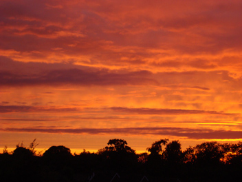
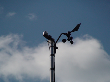
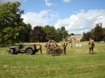
| The month of August 2009 commenced with a rather cloudy day with only occasional brief bursts of sunshine, which totalled only 0.5 hours by the end of the day. A prolonged shower occurred from 1755 GMT to 1930 GMT and this was followed at Royston by the spectacular sunset above (as viewed at 1949 GMT). The photograph shows the trailing edges of an eastward moving cold front, an occurrence which can produce colourful sunsets as above if the front happens to go through just at the right time! The temperature at this time was 15.5°C in a light westerly air of mean speed of 2.6 knots. | This is the anemometer and wind vane in use at Royston (Iceni) Weather Station. It is located on a mast as shown at the standard height of 10 metres above the ground, from where it is here viewed (using a zoom lens!). The instrument is cabled as far as a solar powered transmitter further down the mast which then sends the data by wireless transmission to a remote datalogger for ultimate download to a PC. Also on the mast can be seen the station sunshine recorder as at this height a good view of the celestial dome can be achieved. This instrument is cabled all the way to a remote datalogger. | It is not often military personnel are seen at Anglesey Abbey (28 km NE of Royston) but the normal peace and quiet of this location was punctuated by aircraft and gunfire etc. during a 1940's re-enactment weekend on 22nd/23rd August 2009. The 1940's ground demonstrations and stalls were augmented by a splendid aerial display by a Spitfire put on by the daring female pilot. In this picture taken at 1259 GMT on 22nd the Abbey itself can be seen in the distance, whilst the re-enactors in the foreground are soon to commence firing, and consequently promptly moved on the photographer! |
Return to Welcome to Royston (Iceni) Weather Station page
(This page last updated 16th September 2009 2006 GMT)