
Royston (Iceni) Weather Station
Daily Weather Observations - October 2012
(All Times GMT)
| Date | Max. Temp. (°C) 09/09h | Min. Temp. (°C) 09/09h | Grass Min. Temp. (°C) 21/09h | Earth (30cms) Temp. (°C) 09h | Sun (Hours) 00/00h | R'fall (MM) 09/09h | Wind Dir'n 09h | Mean Wind Speed (MPH) 00/00h | Max. Gust Speed (MPH) 00/00h | Cloud Cover (Oktas) 09h | Mean MSL Air Pressure (mB) 00/00h | Mean Rel. Humd. (%) 00/00h | Mean Temp. (°C) 00/00h | Fog (vis. <1000m @ 09h) | Fog (vis. <200m @ 09h) | Snow or Rain and Snow 00/00h | Snow Lying @ 09h (>50% cover) | Hail 00/00h | Thunder 00/00h | Date |
| 1 | 17.5 | 13.1 | 12.1 | 13.5 | 3.4 | 0.2 | SW | 8.2 | 26 | 8 | 1010.1 | 86.7 | 13.9 | 0 | 0 | 0 | 0 | 0 | 0 | 1 |
| 2 | 17.5 | 9.6 | 7.7 | 13.5 | 4.2 | 0.5 | SW | 9.8 | 29 | 5 | 1007.6 | 84.6 | 13.0 | 0 | 0 | 0 | 0 | 0 | 0 | 2 |
| 3 | 16.4 | 10.1 | 8.0 | 13.5 | 6.3 | 2.7 | SW | 9.5 | 31 | 3 | 1003.7 | 80.3 | 11.2 | 0 | 0 | 0 | 0 | 0 | 0 | 3 |
| 4 | 16.3 | 6.8 | 4.5 | 12.9 | 7.3 | 12.5 | W | 7.4 | 26 | 0 | 1006.6 | 81.2 | 10.7 | 0 | 0 | 0 | 0 | 0 | 0 | 4 |
| 5 | 14.6 | 9.6 | 9.0 | 12.9 | 1.6 | 15.3 | W | 6.5 | 29 | 8 | 1005.6 | 89.7 | 10.8 | 0 | 0 | 0 | 0 | 0 | 0 | 5 |
| 6 | 16.7 | 6.4 | 5.0 | 13.0 | 9.4 | 0.0 | W | 2.5 | 14 | 0 | 1012.3 | 89.6 | 9.2 | 0 | 0 | 0 | 0 | 0 | 0 | 6 |
| 7 | 13.1 | 4.8 | 0.7 | 12.0 | 4.8 | 0.0 | NW | 2.4 | 9 | 8 | 1021.0 | 93.9 | 8.3 | 1 | 0 | 0 | 0 | 0 | 0 | 7 |
| 8 | 13.7 | 7.0 | 2.5 | 11.9 | 2.1 | 0.6 | SE | 1.9 | 16 | 2 | 1014.7 | 92.6 | 11.1 | 0 | 0 | 0 | 0 | 0 | 0 | 8 |
| 9 | 14.5 | 6.5 | 2.9 | 12.2 | 5.7 | 0.0 | SE | 2.3 | 13 | 6 | 1016.1 | 90.2 | 8.9 | 0 | 0 | 0 | 0 | 0 | 0 | 9 |
| 10 | 15.3 | 4.5 | 1.6 | 12.0 | 5.0 | 0.0 | SE | 1.5 | 11 | 6 | 1014.6 | 81.2 | 9.2 | 0 | 0 | 0 | 0 | 0 | 0 | 10 |
| 11 | 14.5 | 5.8 | 2.3 | 11.9 | 1.9 | 3.8 | SE | 5.1 | 20 | 7 | 1003.2 | 91.0 | 11.7 | 0 | 0 | 0 | 0 | 0 | 0 | 11 |
| 12 | 14.6 | 9.9 | 9.0 | 12.4 | 5.9 | 0.4 | W | 10.3 | 31 | 6 | 1003.8 | 84.3 | 10.2 | 0 | 0 | 0 | 0 | 0 | 0 | 12 |
| 13 | 13.9 | 5.5 | 3.1 | 11.8 | 6.5 | 1.8 | S | 5.0 | 18 | 1 | 1003.4 | 90.5 | 7.5 | 0 | 0 | 0 | 0 | 0 | 0 | 13 |
| 14 | 13.6 | 2.8 | -1.0 | 10.9 | 7.4 | TR | W | 5.3 | 20 | 0 | 1001.4 | 88.3 | 6.8 | 0 | 0 | 0 | 0 | 0 | 0 | 14 |
| 15 | 12.9 | 3.9 | -0.7 | 10.4 | 2.0 | 1.6 | S | 7.0 | 26 | 8 | 1000.8 | 88.1 | 8.6 | 0 | 0 | 0 | 0 | 0 | 0 | 15 |
| 16 | 14.6 | 8.5 | 6.6 | 10.9 | 8.3 | 7.0 | SW | 11.5 | 39 | 4 | 998.9 | 77.3 | 10.5 | 0 | 0 | 0 | 0 | 0 | 0 | 16 |
| 17 | 16.5 | 7.6 | 4.7 | 10.7 | 6.6 | 0.3 | SW | 7.8 | 31 | 3 | 996.8 | 84.9 | 12.2 | 0 | 0 | 0 | 0 | 0 | 0 | 17 |
| 18 | 15.5 | 11.3 | 9.2 | 11.3 | 2.1 | TR | S | 6.3 | 20 | 7 | 1001.1 | 86.8 | 13.0 | 0 | 0 | 0 | 0 | 0 | 0 | 18 |
| 19 | 12.5 | 10.9 | 8.4 | 11.6 | 0.0 | 9.7 | CALM | 1.9 | 9 | 8 | 1007.2 | 96.3 | 11.6 | 0 | 0 | 0 | 0 | 0 | 0 | 19 |
| 20 | 13.5 | 7.9 | 5.5 | 11.6 | 1.4 | 3.5 | W | 2.4 | 12 | 8 | 1015.5 | 93.7 | 10.7 | 0 | 0 | 0 | 0 | 0 | 0 | 20 |
| 21 | 12.5 | 8.2 | 6.3 | 11.7 | 0.2 | 5.8 | N | 3.6 | 16 | 7 | 1018.3 | 96.2 | 10.2 | 0 | 0 | 0 | 0 | 0 | 0 | 21 |
| 22 | 14.0 | 10.5 | 10.3 | 11.9 | 0.1 | 0.7 | N | 2.2 | 10 | 8 | 1020.2 | 98.9 | 12.9 | 1 | 1 | 0 | 0 | 0 | 0 | 22 |
| 23 | 13.2 | 10.9 | 10.9 | 12.4 | 0.1 | 0.4 | E | 2.5 | 11 | 8 | 1023.3 | 99.6 | 12.3 | 1 | 1 | 0 | 0 | 0 | 0 | 23 |
| 24 | 15.0 | 12.1 | 11.9 | 12.6 | 0.1 | 0.7 | NE | 4.0 | 15 | 8 | 1019.6 | 100.0 | 13.2 | 1 | 1 | 0 | 0 | 0 | 0 | 24 |
| 25 | 11.7 | 10.4 | 10.2 | 12.9 | 0.1 | TR | NE | 5.8 | 17 | 8 | 1017.0 | 96.2 | 10.5 | 0 | 0 | 0 | 0 | 0 | 0 | 25 |
| 26 | 9.1 | 6.2 | 5.8 | 12.3 | 0.1 | 1.0 | NE | 6.5 | 23 | 8 | 1013.1 | 85.9 | 6.3 | 0 | 0 | 0 | 0 | 0 | 0 | 26 |
| 27 | 7.7 | 0.9 | -1.3 | 10.9 | 4.1 | 1.2 | NW | 7.0 | 31 | 1 | 1016.2 | 89.7 | 3.3 | 0 | 0 | 1 | 0 | 0 | 0 | 27 |
| 28 | 9.0 | 1.4 | -2.1 | 9.5 | 0.1 | 2.8 | SW | 7.0 | 19 | 8 | 1013.3 | 90.9 | 5.9 | 0 | 0 | 0 | 0 | 0 | 0 | 28 |
| 29 | 12.3 | 6.9 | 5.5 | 9.8 | 3.5 | 0.1 | SW | 6.5 | 2.1 | 2 | 1007.2 | 90.7 | 8.4 | 0 | 0 | 0 | 0 | 0 | 0 | 29 |
| 30 | 10.5 | 4.0 | 1.0 | 9.7 | 7.3 | TR | W | 6.1 | 18 | 2 | 1002.8 | 87.4 | 6.5 | 0 | 0 | 0 | 0 | 0 | 0 | 30 |
| 31 | 11.9 | 4.5 | 2.6 | 9.0 | 2.1 | 13.0 | S | 9.6 | 29 | 8 | 987.8 | 84.4 | 8.5 | 0 | 0 | 0 | 0 | 0 | 0 | 31 |
| Total/Mean | 13.7 | 7.4 | 5.2 | 11.7 | 109.3 | 85.6 | X | 5.7 | X | 5.4 | 1009.1 | 89.4 | 9.9 | 4 | 3 | 1 | 0 | 0 | 0 | Total/Mean |
| *Diff./% | -1.0 | -0.7 | 92% | 137% | *Diff./% | |||||||||||||||
| Date | Max. Temp. (°C) 09/09h | Min. Temp. (°C) 09/09h | Grass Min. Temp. (°C) 21/09h | Earth (30cms) Temp. (°C) 09h | Sun (Hours) 00/00h | R'fall (MM) 09/09h | Wind Dir'n 09h | Mean Wind Speed (MPH) 00/00h | Max. Gust Speed (MPH) 00/00h | Cloud Cover (Oktas) 09h | Mean MSL Air Pressure (mB) 00/00h | Mean Rel. Humd. (%) 00/00h | Mean Temp. (°C) 00/00h | Fog (vis. <1000m @ 09h) | Fog (vis. <200m @ 09h) | Snow or Rain and Snow 00/00h | Snow Lying @ 09h (>50% cover) | Hail 00/00h | Thunder 00/00h | Date |
Differences from average:
Differences from average shown in red. Reference periods used are as follows: Temperature 30 Years 1981/2010; rainfall 30 Years 1981/2010; sunshine 30 Years 1981/2010.
(*The differences from average quoted during the course of the month relate to the cumulative daily averages up to the date of the last observation, not the averages for the month as a whole)
Additional Data:
Rainfall Duration N/A
Air Frost Duration NIL hours
Graphs and Charts:
Click on the following links to view this month's graphs and charts.....
1. Daily Maximum, Minimum & Grass Minimum Temperatures
2. Daily Maximum & Minimum Temperatures (with 30 Year Comparative Means)
3. Daily Earth (30 cms Depth) Temperature @ 0900 GMT 4. Daily Rainfall 5. Daily Sunshine
6. Daily Maximum Gust & Mean Wind Speed 7. Daily Wind Direction @ 0900 GMT
8. Daily Mean MSL Air Pressure 9. Daily Mean Relative Humidity 10. Thermograph
11. Barograph 12. Hygrograph 13. Anemograph 14. Wind Direction
15. Rainfall Intensity & Duration
October 2012 Weather Review:
......and click on the link below for a text report of the October 2012 weather in Royston
October (since 1972) at Royston (Iceni) Weather Station:
Mean day maximum temperature (30 years 1981/2010) 14.7°C
Mean night minimum temperature (30 years 1981/2010) 8.1°C
Highest temperature 29.0°C (1st October 2011); lowest temperature -3.6°C (29th October 1997)
Lowest grass minimum temperature -8.3°C (29th October 1997)
Warmest October 2001 (Mean temperature 14.3°C); coldest October 1974 (Mean temperature 7.3°C)
Highest no. of days with air frost 5 (1997); highest no. of days with ground frost 13 (2003)
Average October rainfall (30 years 1981/2010) 62.6 mm
Wettest October 2001 (Rainfall 137.8 mm); driest October 1972 (Rainfall 4.1 mm)
Wettest Day 20th October 2001 (Rainfall 51.8 mm);
Highest number of "rain days" (0.2 mm or more) 23 (2000); lowest number of "rain days" 3 (1972)
Highest number of days with thunder 3 (1984)
|
|
|
|
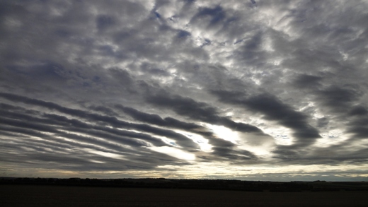
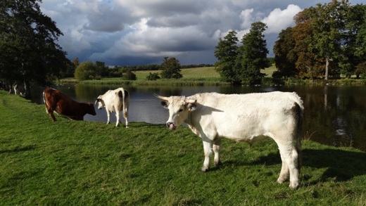
| In the morning of 5th October 2012 an unusual display of banded cloud was visible from Royston in the western sky. Within about 20 minutes this display had moved overhead and into the eastern sky and over the rising sun. This picture was taken at 0731 GMT to the east of the town looking towards the village of Barley. The original display showed white cloud with a light grey base whereas the backlighting by the sun has rendered the display much darker. The 0600 GMT synoptic chart shows a cold front (linked to a small low (central pressure 996 mB) lying just east of Great Yarmouth) clearing south-east England whilst the radar images later in the morning show the rain band on this front fragmenting over the English Channel whilst maintaining a very narrow strip of heavier rain over the Cherbourg peninsula. The wind at the surface at this time was westerly, of mean speed 6 knots gusting to 11 knots. The temperature was 9.9°C, later rising to a maximum of 14.6°C, whilst the day was mainly cloudy with only 1.6 hours sunshine. | One of the features of the Wimpole estate which lies some 10 km N of Royston is the Home Farm collection of rare breeds of cattle, horses, sheep, goats, pigs and chickens. This is one of the UK's largest rare breeds centres and plays a key role in the conservation of rare and traditional breeds of livestock. In this view as seen at 1356 GMT on 13th October 2012 a number of cows have come down to the lake for a drink, the one nearest the camera being a White Park, a member of probably the most ancient breed of cattle native to the British Isles. Cattle of a similar type are thought to have originated in the 5th Century BC in several locations in the British Isles. At the onset of World War II some animals were transported to North America to help preserve the breed. The White Park at Wimpole must be used to the many visitors to the park and invariably seem to be of a friendly disposition. Whilst sunny at this time (6.5 hours for the day at Royston) the black clouds on the horizon herald a shower to come. | In the early evening of 20th October 2012 the station met. observer received a report from Stevenage (19 km SW of Royston) of a vivid sunset there, and quickly ventured outside to check on the position at Royston. This proved a worthwhile excursion as illustrated by the picture above (taken at 1705 GMT) which shows a similar attractive sunset which was just at its maximum intensity. As is often the case such sunsets come and go very quickly so it was somewhat fortuitous to catch it at this moment. The day had been essentially cloudy (sunshine 1.4 hours) in a weak ridge of high pressure covering the southern half of Great Britain, with a warm front approaching SE England in the evening. At this time the British Isles was flanked by an anticyclone over central and eastern Europe and a deep low in mid-Atlantic. As regards the weather conditions in Royston a SW light breeze of mean speed 1 knot gusting to 3 knots was in evidence, and the temperature was 11.8°C after a maximum for the day of 13.5°C. Overall the month had been sunny but wet up to 20th. |
Return to Welcome to Royston (Iceni) Weather Station page
(This page last updated 9th November 2012 2108 GMT)