Royston (Iceni) Weather Station
Daily Weather Observations - February 2010
(All Times GMT)
| Date | Max. Temp. (°C) 09/09h | Min. Temp. (°C) 09/09h | Grass Min. Temp. (°C) 21/09h | Earth (30cms) Temp. (°C) 09h | Sun (Hours) 00/00h | R'fall (MM) 09/09h | Wind Dir'n 09h | Mean Wind Speed (MPH) 00/00h | Max. Gust Speed (MPH) 00/00h | Cloud Cover (Oktas) 09h | Mean MSL Air Pressure (mB) 00/00h | Mean Rel. Humd. (%) 00/00h | Mean Temp. (°C) 00/00h | Fog (vis. <1000m @ 09h) | Fog (vis. <200m @ 09h) | Snow or Rain and Snow 00/00h | Snow Lying @ 09h (>50% cover) | Hail 00/00h | Thunder 00/00h | Date |
| 1 | 5.3 | -1.9 | -4.5 | 2.9 | 7.7 | TR | W | 7.8 | 18 | 0 | 1011.9 | 83.4 | 0.7 | 0 | 0 | 0 | 0 | 0 | 0 | 1 |
| 2 | 8.0 | 1.2 | -0.5 | 2.5 | 0.5 | 5.1 | SW | 10.5 | 31 | 8 | 1004.8 | 87.5 | 4.7 | 0 | 0 | 0 | 0 | 0 | 0 | 2 |
| 3 | 7.5 | -0.5 | -3.5 | 2.6 | 0.9 | 1.4 | SW | 5.0 | 21 | 8 | 1007.4 | 90.2 | 2.5 | 0 | 0 | 0 | 0 | 0 | 0 | 3 |
| 4 | 8.2 | 5.2 | 3.3 | 3.1 | 0.0 | 2.5 | S | 5.8 | 19 | 8 | 1004.6 | 90.8 | 6.5 | 0 | 0 | 0 | 0 | 0 | 0 | 4 |
| 5 | 9.9 | 4.2 | 3.1 | 3.9 | 4.1 | 0.2 | SW | 5.5 | 17 | 8 | 999.9 | 86.3 | 6.1 | 0 | 0 | 0 | 0 | 0 | 0 | 5 |
| 6 | 4.7 | 0.0 | -3.0 | 4.2 | 0.0 | 0.2 | NE | 3.0 | 17 | 8 | 1014.3 | 94.2 | 2.8 | 0 | 0 | 0 | 0 | 0 | 0 | 6 |
| 7 | 4.5 | 2.5 | 0.2 | 4.0 | 0.0 | 0.6 | N | 3.4 | 14 | 8 | 1022.2 | 94.5 | 3.0 | 1 | 0 | 0 | 0 | 0 | 0 | 7 |
| 8 | 1.2 | 0.9 | 0.5 | 4.2 | 0.0 | 1.1 | NE | 7.0 | 25 | 8 | 1013.0 | 90.7 | 0.8 | 0 | 0 | 1 | 0 | 0 | 0 | 8 |
| 9 | 5.8 | -1.5 | -5.0 | 3.9 | 4.7 | 0.1 | N | 5.9 | 26 | 4 | 1011.8 | 83.4 | 1.5 | 0 | 0 | 1 | 0 | 0 | 0 | 9 |
| 10 | 3.0 | -0.1 | -2.4 | 3.6 | 4.9 | 1.1 | N | 7.3 | 27 | 8 | 1016.4 | 83.0 | 0.3 | 0 | 0 | 1 | 0 | 0 | 0 | 10 |
| 11 | 3.0 | -1.5 | -3.7 | 3.3 | 4.5 | 1.6 | NE | 7.0 | 25 | 7 | 1021.5 | 75.6 | 0.5 | 0 | 0 | 1 | 1 | 0 | 0 | 11 |
| 12 | 4.1 | 0.4 | -0.1 | 3.0 | 0.1 | 0.5 | N | 3.7 | 16 | 8 | 1022.9 | 89.7 | 2.1 | 0 | 0 | 1 | 0 | 0 | 0 | 12 |
| 13 | 3.5 | -1.0 | -3.9 | 3.4 | 0.5 | 0.9 | N | 3.9 | 17 | 8 | 1022.0 | 86.7 | 1.1 | 0 | 0 | 1 | 0 | 0 | 0 | 13 |
| 14 | 4.9 | -0.1 | -2.0 | 3.4 | 0.0 | 0.3 | N | 2.5 | 15 | 8 | 1015.7 | 89.1 | 2.0 | 0 | 0 | 0 | 0 | 0 | 0 | 14 |
| 15 | 4.0 | -1.7 | -5.5 | 3.5 | 0.0 | 1.7 | E | 4.5 | 20 | 8 | 1005.1 | 85.0 | 0.8 | 0 | 0 | 1 | 0 | 0 | 0 | 15 |
| 16 | 5.0 | 2.4 | 1.4 | 3.5 | 0.0 | 3.8 | S | 6.7 | 22 | 7 | 992.4 | 89.4 | 3.7 | 0 | 0 | 0 | 0 | 0 | 0 | 16 |
| 17 | 7.5 | 1.1 | 0.5 | 3.9 | 5.2 | 0.1 | SE | 2.6 | 11 | 8 | 990.8 | 85.0 | 2.9 | 0 | 0 | 0 | 0 | 0 | 0 | 17 |
| 18 | 3.9 | -1.8 | -6.0 | 3.8 | 0.0 | 8.2 | SE | 2.2 | 15 | 7 | 989.8 | 92.0 | 1.3 | 0 | 0 | 1 | 0 | 0 | 0 | 18 |
| 19 | 4.4 | 0.1 | -0.1 | 3.5 | 2.1 | 0.0 | W | 7.0 | 20 | 6 | 992.5 | 87.1 | 1.6 | 0 | 0 | 1 | 1 | 0 | 0 | 19 |
| 20 | 5.8 | -1.5 | -4.0 | 3.5 | 4.9 | 1.5 | W | 4.4 | 14 | 3 | 996.6 | 83.7 | 0.9 | 0 | 0 | 0 | 0 | 0 | 0 | 20 |
| 21 | 6.5 | -0.9 | -2.4 | 3.1 | 2.1 | 8.1 | SE | 4.9 | 22 | 8 | 992.4 | 88.3 | 2.0 | 0 | 0 | 1 | 1 | 0 | 0 | 21 |
| 22 | 1.7 | 0.0 | -0.5 | 3.1 | 0.0 | 3.4 | NE | 4.3 | 19 | 8 | 987.3 | 91.5 | 1.0 | 0 | 0 | 1 | 1 | 0 | 0 | 22 |
| 23 | 5.3 | -1.0 | -4.8 | 3.0 | 0.0 | 3.3 | NE | 3.6 | 16 | 8 | 992.7 | 90.4 | 0.9 | 0 | 0 | 1 | 1 | 0 | 0 | 23 |
| 24 | 9.5 | 1.6 | 0.4 | 3.0 | 0.8 | 2.6 | S | 4.6 | 16 | 8 | 989.9 | 92.4 | 6.2 | 0 | 0 | 0 | 0 | 0 | 0 | 24 |
| 25 | 9.5 | 5.4 | 3.9 | 3.9 | 0.1 | 4.0 | SW | 4.7 | 20 | 8 | 986.0 | 89.6 | 7.0 | 0 | 0 | 0 | 0 | 0 | 0 | 25 |
| 26 | 6.8 | 4.3 | 3.9 | 4.8 | 0.3 | 2.6 | W | 14.1 | 38 | 8 | 987.0 | 80.3 | 5.4 | 0 | 0 | 0 | 0 | 0 | 0 | 26 |
| 27 | 10.1 | 2.8 | 0.5 | 4.5 | 1.8 | 6.1 | S | 5.9 | 25 | 7 | 992.3 | 86.9 | 6.1 | 0 | 0 | 0 | 0 | 0 | 0 | 27 |
| 28 | 5.1 | 4.5 | 3.2 | 5.0 | 0.0 | 6.8 | N | 8.3 | 25 | 8 | 988.9 | 88.0 | 4.3 | 0 | 0 | 0 | 0 | 0 | 0 | 28 |
| Total/Mean | 5.7 | 0.8 | -1.1 | 3.6 | 44.8 | 67.8 | X | 5.6 | X | 7.2 | 1002.6 | 87.7 | 2.8 | 1 | 0 | 12 | 5 | 0 | 0 | Total/Mean |
| *Diff./% | -1.5 | -1.0 | 62% | 194% | *Diff./% | |||||||||||||||
| Date | Max. Temp. (°C) 09/09h | Min. Temp. (°C) 09/09h | Grass Min. Temp. (°C) 21/09h | Earth (30cms) Temp. (°C) 09h | Sun (Hours) 00/00h | R'fall (MM) 09/09h | Wind Dir'n 09h | Mean Wind Speed (MPH) 00/00h | Max. Gust Speed (MPH) 00/00h | Cloud Cover (Oktas) 09h | Mean MSL Air Pressure (mB) 00/00h | Mean Rel. Humd. (%) 00/00h | Mean Temp. (°C) 00/00h | Fog (vis. <1000m @ 09h) | Fog (vis. <200m @ 09h) | Snow or Rain and Snow 00/00h | Snow Lying @ 09h (>50% cover) | Hail 00/00h | Thunder 00/00h | Date |
Differences from average:
Differences from average shown in red. Reference periods used are as follows: Temperature 30 Years 1976/2005; rainfall 30 Years 1971/2000; sunshine 30 Years 1971/2000.
(*The differences from average quoted during the course of the month relate to the cumulative daily averages up to the date of the last observation, not the averages for the month as a whole)
Additional Data:
Rainfall Duration N/A
Air Frost Duration 87.2 hours
Graphs and Charts:
Click on the following links to view this month's graphs and charts.....
1. Daily Maximum, Minimum & Grass Minimum Temperatures
2. Daily Maximum & Minimum Temperatures (with 30 Year Comparative Means)
3. Daily Earth (30 cms Depth) Temperature @ 0900 GMT 4. Daily Rainfall 5. Daily Sunshine
6. Daily Maximum Gust & Mean Wind Speed 7. Daily Wind Direction @ 0900 GMT
8. Daily Mean MSL Air Pressure 9. Daily Mean Relative Humidity 10. Thermograph
11. Barograph 12. Hygrograph 13. Anemograph 14. Wind Direction
February 2010 Weather Review:
......and click on the link below for a text report of the February 2010 weather in Royston
February (since 1973) at Royston (Iceni) Weather Station:
Mean day maximum temperature (30 years 1976/2005) 7.2°C
Mean night minimum temperature (30 years 1976/2005) 1.8°C
Highest temperature 18.5°C (13th February 1998); lowest temperature -10.5°C (12th & 13th February 1985)
Lowest grass minimum temperature -14.5°C (10th February 1986)
Warmest February 1990 (Mean temperature 8.1°C); coldest February 1986 (Mean temperature -1.6°C)
Average February rainfall (30 years 1971/2000) 35.0 mm
Wettest February 2001 (Rainfall 90.7 mm); driest February 1998 (Rainfall 4.8 mm)
Wettest Day 7th February 2001 (Rainfall 21.8 mm);
Highest number of "rain days" (0.2 mm or more) 21 (2000); lowest number of "rain days" 5 (1998)
Highest number of days with thunder 2 (1995)
Highest number of air frosts 24 (1986)
Highest number of ground frosts 25 (1986)
Highest number of days with snow falling 15 (1986)
Highest number of days with snow lying (ground with more than 50% snow cover @ 0900 GMT) 23 (1986)
|
|
|
|
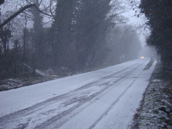
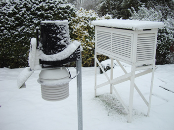
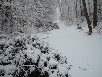
| An early morning snow shower was in progress when this photograph was taken and snow has quickly covered the Newmarket Road in Royston on 10th February 2010 (at 0849 GMT). The location is adjacent to the Newmarket Road Playing Field looking westwards towards the centre of Royston. Although the local roads were slippery for a time the weather later improved and the snow had mostly thawed by the middle of the day. The temperature at this time was 0.4°C (with a NNE wind of mean speed 8 knots gusting to 13 knots) and later rose to a maximum of 3.0°C. Sunshine for the day was 4.9 hours. | This is a nightmare scenario for measuring rainfall! The automatic rain gauge in the picture is clogged with snow and will not record the rainfall equivalent of the snow until a thaw occurs. Two other recording rain gauges nearby are in the same situation. The funnel from the manual M O Mk 1A rain gauge also nearby can be taken indoors and the snow melted and the resultant water can then be measured as normal. This is usually a slow process but is does enable the rainfall to be recorded against the correct day. The date is 22nd February 2010 (at 0837 GMT) and the snow on the ground is 6 cm deep. | With reference to the adjacent photograph which shows some of the instrumentation at Royston (Iceni) Weather Station, a little later in the morning of 22nd February 2010 (at 0916 GMT) this was the scene in the Newmarket Road Plantation, Royston. The track through the plantation as seen here leads up to the top of Hyde Hill where there is a radio tower for telephone communication. The temperature is 0.4°C (later rising to a day maximum of 1.7°C) in a NE wind of mean speed 4 knots gusting to 9 knots. A NIL sunshine value was recorded that day and this was the 9th such day with no sunshine in the month to date. |
Return to Welcome to Royston (Iceni) Weather Station page
(This page last updated 13th March 2010 2049 GMT)